Auckland Day Walks — Our EBC Training Routes
This article contains affiliate links. If you book or purchase through these links I may earn a small commission at no extra cost to you. I only recommend products and companies I genuinely use or have researched thoroughly.
Most of our EBC preparation has happened at the Auckland Altitude Training Centre — masks, treadmills, and hypoxic machines. But the other half of training for a multi-week mountain trek is simply getting out and walking on real terrain with real elevation.
We’ve been working through a list of Auckland day walks over the past year — some old favourites, some new discoveries, all with an eye on what builds the specific fitness that EBC demands: sustained uphill, loaded pack, and the ability to repeat it the next day. Here’s the full list, with honest notes on each.
A Note on Kauri Dieback
Several of the best walks in the Waitakere Ranges remain closed due to kauri dieback — the fungal disease threatening New Zealand’s ancient kauri trees. Before heading out on any Waitakere track, check the Auckland Council kauri dieback map for current closures. Boot cleaning stations are mandatory at all open tracks — take them seriously.
The good news: several tracks including Zion Hill and Kuataika have recently reopened after major restoration work, which has made the Waitakeres significantly more accessible than they were in 2022–2024.
1. Te Aroha Summit Loop
Location: Te Aroha, Waikato | Distance: ~15km | Elevation: 952m | Difficulty: Hard | Drive from Auckland: ~1.5 hours
The furthest drive on this list, the most demanding walk and perhaps a little controversial as it is in Waikato — the one that earned its own category in our training programme.
Te Aroha Summit Track begins in the Te Aroha Domain on Whitaker St and climbs almost 1km in height over a 3.9km track. It’s very steep — the average gradient is unrelenting, the surface roughens significantly in the upper section, and the last quarter is particularly challenging.
We covered the 900m+ ascent in 2 hours 15 minutes — and it was the first walk where we genuinely felt the altitude training sessions working. The effort at pace felt different from previous climbs, in the right way.
At 952m, Te Aroha is the highest peak in the Kaimai-Mamaku Forest Park, offering great views across the Waikato and Bay of Plenty — on a clear day you can see Ruapehu, Ngāuruhoe, and Taranaki. This is as close as Auckland gets to a Munro — the same elevation, the same character, the same earned summit feeling.
We didn’t fancy the steep descent back down the summit track so tried the loop route down. We struggled to find it, and ended up walking a good chunk of the descent on the gravel service road for the TV tower — which brings you out at the other end of Te Aroha town. A 15km day in total, not entirely as planned. Take a downloaded map. And take the descent slowly regardless of which way you go.
2. Ōmanawanui Track
Location: Whatipu, West Auckland | Distance: ~7.7km return | Elevation: 373m | Difficulty: Moderate | Drive from Auckland: ~1 hour 15 minutes
Possibly the most spectacular day walk in Auckland — and one of our favourites. The views across the Manukau Harbour entrance to the Manukau Heads are extraordinary — dramatic coastal geography at its finest.
The track climbs approximately 373m, winding through regenerating native bush, low scrubland, and past exposed rock faces to a ridge offering stunning views of the harbour and surrounding area. There are around 2,400 built stairs — your legs will know about it.
The track can be technically demanding in places, and since the kauri dieback closure the route is an out-and-back — you can’t do the original loop. The alternative is walking back down the road to Whatipu, which can be busy. Most people simply retrace their steps, which honestly gives you better views on the descent anyway.
The drive from Auckland on the Titirangi road narrows to single-lane gravel for the last section — allow extra time and take it carefully. Worth every minute of the drive.
3. Exhibition Drive, Beveridge, Slip, Pipeline Loop
Location: Titirangi, West Auckland | Distance: ~13km | Elevation: ~450m | Difficulty: Moderate | Drive from Auckland: ~35 minutes
The most accessible Waitakere walk on this list — the trailhead is close to Titirangi, making it a realistic after-work or weekend morning option without a long drive.
The route starts with the flat Exhibition Drive to Mackies Rest — a gentle warm-up through bush that lets you find your rhythm before the climbing begins. From Mackies Rest, Beveridge Track turns uphill into the Waitakere bush proper, climbing to the Arataki Visitor Centre at the top. Arataki is always worth a visit — interpretive displays, a fantastic carved wharenui, and great views down over the reservoirs toward Manukau Harbour. A natural rest stop that doesn’t feel like an excuse to stop.
From Arataki, Slip Track drops back down into the bush before Pipeline connects back to Exhibition Drive at Mackies Rest. Thirteen kilometres in total, a satisfying loop with enough variety to keep it interesting, and the Beveridge climb is a solid leg workout without being brutal.
4. Kuataika Track
Location: Anawhata Road, West Auckland | Distance: ~8.9km return | Elevation: 520m | Difficulty: Moderate-Hard | Drive from Auckland: ~1 hour
Kuataika Track is located near Piha in Waitakere Ranges Regional Park, taking you through the forest to Kuataika Trig with lovely views. Be prepared for steep sections and stream crossings.
The track opens with farmland — crossing a stile into Anawhata Farm Regional Park and following markers through open paddocks with big Tasman Sea views — before dropping into the bush. The swing bridge over Anawhata Stream is one of the better trail features in the Waitakeres. The trig at the top gives wide views over the ranges and coast.
The parking area on Anawhata Road is small and fills early on weekends — get there by 8am or plan for roadside parking. This is one of the recently reopened tracks and deservedly popular now that it’s accessible again.
5. Wairoa Loop Track
Location: Hunua Ranges, South Auckland | Distance: ~9km | Elevation: ~455m | Difficulty: Moderate | Drive from Auckland: ~1 hour
The Hunua Ranges offer something different to the Waitakeres — no kauri dieback restrictions, a different forest character, and the dramatic reservoir infrastructure that supplies most of Auckland’s drinking water.
The Wairoa Loop Track is a forest walk featuring views of the Hunua Ranges and its impressive reservoirs — an excellent day trip to get your forest fix right on Auckland’s doorstep. The track mixes ridgeline walking with forest descent, stream crossings, and a suspension bridge that’s a highlight of the route.
Well-maintained with a good mix of flat ground, steep stairs, forest hills, and beautiful lookouts. Solid legs workout without being punishing — a good recovery day walk after harder efforts on Te Aroha or Omanawanui.
6. Zion Hill and Pararaha Valley
Location: Karekare, West Auckland | Distance: ~8.7km | Elevation: ~470m | Difficulty: Moderate | Drive from Auckland: ~1 hour
This track reopened in early 2026 after being closed since 2018 for kauri dieback management and storm repair — one of the more significant track reopenings in the Waitakeres in recent years.
The Zion Hill Track Loop delivers rugged beauty with dramatic climbs, sweeping vistas, and a grand finale on the black sands of Karekare beach. The track begins from the Karekare car park, rises sharply through regenerating coastal forest to Mount Zion at 263m, with views of raw cliffs, rolling headlands, and the Tasman Sea. The Pararaha Valley extension adds the valley floor section — nikau palms, old tramway remnants, and dune crossings — before meeting Karekare Beach.
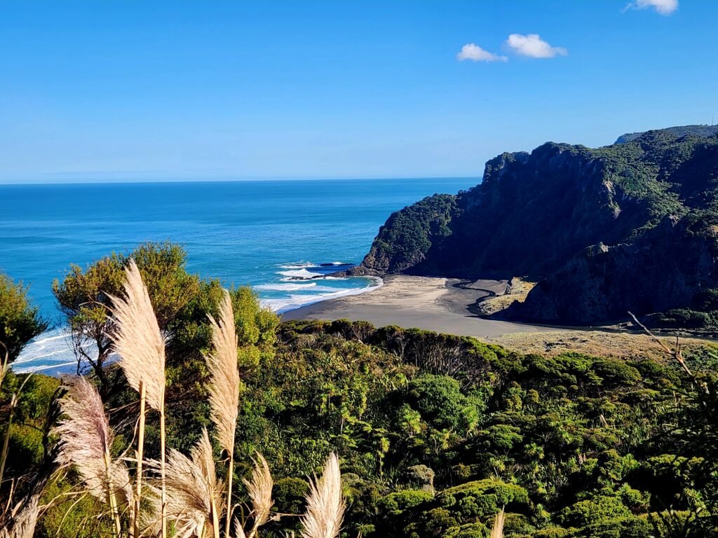
Note that as of February 2026, Zion Ridge Track and Buck Taylor Track were still closed — check the Auckland Council kauri dieback map for current status before planning the full loop. The Zion Hill out-and-back with Pararaha Valley remains excellent regardless.
7. Cutty Grass Track
Location: Waitakere Ranges | Difficulty: Moderate | Drive from Auckland: ~45 minutes
The Cutty Grass Track winds through dense Waitakere bush from Scenic Drive— a quieter alternative to some of the more popular Waitakere routes. Less dramatic than Omanawanui but excellent for sustained bush walking and the kind of uneven, rooty terrain that conditions ankles and feet for multi-day trekking.
Worth combining with neighbouring tracks for a longer day out. Check current kauri dieback status before visiting.
What These Walks Built
Taken together across the months leading up to departure, these seven walks have served three purposes:
Cardiovascular endurance — sustained uphill at real pace, particularly Te Aroha and Omanawanui, builds the aerobic base that altitude training reinforces but can’t replace.
Pack-carrying conditioning — we’ve been doing most of these with loaded daypacks, progressively increasing the weight to mirror what the EBC daypack will feel like on day eight.
Mental familiarity with discomfort — knowing what four hours of sustained walking in NZ conditions feels like, and being comfortable in that effort zone, is preparation that doesn’t show up in any fitness metric.
None of these walks are at altitude. The highest point — Te Aroha at 952m — is well below Lukla at 2,860m. But the training effect is cumulative, and arriving in Nepal with legs that know what sustained uphill feels like is a better starting point than fresh legs that don’t.
More From Above the Cloud Treks
- How to Train for Everest Base Camp
- Kepler Track — New Zealand Great Walk Guide
- Greenstone-Caples Track Guide
- EBC Trek Fitness Requirements
- EBC Trek Mental Preparation
Andrew Dillon is a data consultant, runner, and triathlete based in Auckland, New Zealand. He is trekking EBC via Gokyo with Evertrek in October 2026. Follow his journey at abovethecloudtreks.com.